File:EU-Portugal.svg

Size of this PNG preview of this SVG file: 713 × 600 pixelwo. Other resolutions: 285 × 240 pixelwo | 571 × 480 pixelwo | 913 × 768 pixelwo | 1,218 × 1,024 pixelwo | 2,435 × 2,048 pixelwo | 2,045 × 1,720 pixelwo.
Gbale adoduia (SVG file, nominally 2,045 × 1,720 pixels, file size: 7.33 MB)
Nya kpui aɖe
| Numeɖeɖe |
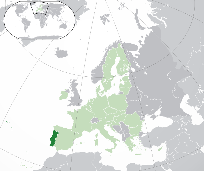
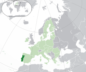
English: (Dark-Green) Portugal. (Light-Green) The rest of the European Union (EU). (Dark-gray) The rest of Europe. (Light-gray) The surrounding region.
See also: |
| SVG genesis | |
| Ŋkeke | |
| Nyatakatsoƒe | |
| Ewɔla | NuclearVacuum |
| Other versions |
Derivative works of this file: EU-Portugal with islands circled.svg |
Licensing
I, the copyright holder of this work, hereby publish it under the following licenses:
This file is licensed under the Creative Commons Attribution-Share Alike 3.0 Unported license.
- You are free:
- na ma – to copy, distribute and transmit the work
- to remix – to adapt the work
- Under the following conditions:
- attribution – You must give appropriate credit, provide a link to the license, and indicate if changes were made. You may do so in any reasonable manner, but not in any way that suggests the licensor endorses you or your use.
- miakpɔ gome ɖekae – If you remix, transform, or build upon the material, you must distribute your contributions under the same or compatible license as the original.

|
Permission is granted to copy, distribute and/or modify this document under the terms of the GNU Free Documentation License, Version 1.2 or any later version published by the Free Software Foundation; with no Invariant Sections, no Front-Cover Texts, and no Back-Cover Texts. A copy of the license is included in the section entitled GNU Free Documentation License. |
You may select the license of your choice.
Nutsɔ ʋuvayiwo
Tia ŋkeke/gaƒoƒo ɖeka ne wòadi be yea kpɔ axa sia ƒe tata le ɣemaɣi
| Ŋkeke/Gaƒoƒo | Nɔnɔmetata sue aɖe | Goglome | Ezãla | Comment | |
|---|---|---|---|---|---|
| fifia | 05:28, 1 Dzodze 2020 | | 2,045 × 1,720 (7.33 MB) | Rob984 | UK and Gibraltar have left the EU. New base which includes all of Portugal's islands within frame, as well as Arctic Russian islands part of Europe. Also fixed Flevoland in the Netherlands. |
| 20:34, 25 Kele 2016 |  | 2,045 × 1,720 (7.32 MB) | Giorgi Balakhadze | + some lakes | |
| 04:06, 23 Siamlɔm 2015 |  | 2,045 × 1,720 (2.6 MB) | Polyethylen | Reverted to version as of 09:38, 1 July 2013 | |
| 02:58, 23 Siamlɔm 2015 |  | 929 × 577 (1.11 MB) | Viet-hoian1 | Map | |
| 09:38, 1 Siamlɔm 2013 |  | 2,045 × 1,720 (2.6 MB) | U5K0 | croatia | |
| 22:42, 21 Tedoxe 2010 |  | 2,045 × 1,720 (2.6 MB) | Pethrus | Added islands of Corvo and Flores (Azores) and the Desertas and Savage islands (Madeira) | |
| 14:43, 23 Kele 2009 |  | 2,045 × 1,720 (2.59 MB) | NuclearVacuum | consensus version | |
| 18:26, 18 Kele 2009 |  | 2,045 × 1,720 (2.62 MB) | NuclearVacuum | final version | |
| 17:52, 17 Kele 2009 |  | 680 × 520 (530 KB) | NuclearVacuum | new | |
| 05:09, 17 Kele 2009 |  | 680 × 520 (526 KB) | NuclearVacuum | red coloring |
Nyatakagbaa zazã
Axa sia ku ɖe agbalẽ sia ŋu:
Xexe me godoo ƒe agbale zaza
The following other wikis use this file:
- Ezã ady.wikipedia.org
- Ezã als.wikipedia.org
- Ezã ar.wikipedia.org
- مستخدم:جار الله/قائمة صور مقالات العلاقات الثنائية
- العلاقات البرتغالية الأمريكية
- العلاقات الأنغولية البرتغالية
- العلاقات البرتغالية الكورية الجنوبية
- العلاقات البرتغالية الإريترية
- العلاقات البرتغالية السويسرية
- العلاقات الألمانية البرتغالية
- العلاقات البرتغالية الليختنشتانية
- العلاقات البرتغالية البوليفية
- العلاقات البرتغالية الموزمبيقية
- العلاقات الألبانية البرتغالية
- العلاقات البرتغالية البلجيكية
- العلاقات البرتغالية الإثيوبية
- العلاقات البرتغالية البيلاروسية
- العلاقات البرتغالية الطاجيكستانية
- العلاقات البرتغالية الروسية
- العلاقات البرتغالية الرومانية
- العلاقات الأرجنتينية البرتغالية
- العلاقات البرتغالية الغامبية
- العلاقات البرتغالية القبرصية
- العلاقات البرتغالية السيراليونية
- العلاقات البرتغالية النيبالية
- العلاقات البرتغالية الليبيرية
- العلاقات البرتغالية التشيكية
- العلاقات البرتغالية الميانمارية
- العلاقات البرتغالية الكندية
- العلاقات البرتغالية الزيمبابوية
- العلاقات البرتغالية الإسرائيلية
- العلاقات البرتغالية البالاوية
- العلاقات البرتغالية المالية
- العلاقات البرتغالية النيجيرية
- العلاقات البرتغالية اليمنية
- العلاقات البرتغالية الفانواتية
- العلاقات البرتغالية الغابونية
- العلاقات البرتغالية البنمية
- العلاقات البرتغالية الكوبية
- العلاقات البرتغالية الجورجية
- العلاقات البرتغالية التونسية
- العلاقات البرتغالية الكورية الشمالية
- العلاقات البرتغالية اليابانية
- العلاقات البرتغالية الإيطالية
- العلاقات البرتغالية الناوروية
- العلاقات الأسترالية البرتغالية
- العلاقات البرتغالية الزامبية
- العلاقات البرتغالية الفيجية
- العلاقات البرتغالية المارشالية
- العلاقات الأذربيجانية البرتغالية
- العلاقات البرتغالية السودانية
View more global usage of this file.