File:Eswatini Regions map.png

Hafi nakpɔ alesi eƒe lolome le :524 × 600 pixelwo. Other resolutions: 210 × 240 pixelwo | 419 × 480 pixelwo | 671 × 768 pixelwo | 895 × 1,024 pixelwo | 2,000 × 2,289 pixelwo.
Gbale adoduia (2,000 × 2,289 pixels, file size: 13.12 MB, MIME type: image/png)
Nya kpui aɖe
| Numeɖeɖe |
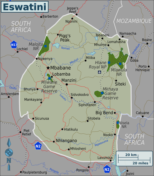
English: Map of Eswatini with regions colour coded. Map of Eswatini, Eswatini |
| Ŋkeke | |
| Nyatakatsoƒe | :image:Eswatini Regions map.svg |
| Ewɔla | User:(WT-shared) Burmesedays, Perry-Castañeda Library Map Collection Swaziland Maps |
Licensing
This file is licensed under the Creative Commons Attribution-Share Alike 3.0 Unported license.
- You are free:
- na ma – to copy, distribute and transmit the work
- to remix – to adapt the work
- Under the following conditions:
- attribution – You must give appropriate credit, provide a link to the license, and indicate if changes were made. You may do so in any reasonable manner, but not in any way that suggests the licensor endorses you or your use.
- miakpɔ gome ɖekae – If you remix, transform, or build upon the material, you must distribute your contributions under the same or compatible license as the original.
Original upload log
| This file was imported from Wikivoyage WTS. |
The original description page was here. All following user names refer to wts.wikivoyage-old.
- 2010-03-07 09:32 (WT-shared) Burmesedays[dead link] 2486×2941 (1670211 bytes) {{Imagecredit|credit=[[User:Burmesedays]], [http://lib.utexas.edu/maps/swaziland.html Perry-Castañeda Library Map Collection Swaziland Maps (Import from wikitravel.org/shared)
- 2010-03-07 13:25 (WT-shared) Burmesedays[dead link] 2486×2941 (1685930 bytes) added SA route shields (Import from wikitravel.org/shared)
- 2010-03-08 03:40 (WT-shared) Burmesedays[dead link] 2486×2941 (1645332 bytes) with regions turned off as per talk (Import from wikitravel.org/shared)
- 2010-03-08 04:10 (WT-shared) Burmesedays[dead link] 2486×2941 (1645355 bytes) (Import from wikitravel.org/shared)
Nutsɔ ʋuvayiwo
Tia ŋkeke/gaƒoƒo ɖeka ne wòadi be yea kpɔ axa sia ƒe tata le ɣemaɣi
| Ŋkeke/Gaƒoƒo | Nɔnɔmetata sue aɖe | Goglome | Ezãla | Comment | |
|---|---|---|---|---|---|
| fifia | 05:34, 9 Dasiamime 2020 | | 2,000 × 2,289 (13.12 MB) | Bestoernesto | Moved the International Airport to the right place |
| 19:19, 8 Tedoxe 2019 |  | 2,000 × 2,289 (1.08 MB) | Shaundd | Swaziland > Eswatini, changes to improve readability, reframe map so more focus on Eswatini | |
| 01:10, 19 Dzome 2012 |  | 2,486 × 2,941 (1.57 MB) | OgreBot | (BOT): Reverting to most recent version before archival | |
| 01:10, 19 Dzome 2012 |  | 2,486 × 2,941 (1.57 MB) | OgreBot | (BOT): Uploading old version of file from wts.wikivoyage; originally uploaded on 2010-03-08 03:40:17 by (WT-shared) Burmesedays | |
| 01:10, 19 Dzome 2012 |  | 2,486 × 2,941 (1.61 MB) | OgreBot | (BOT): Uploading old version of file from wts.wikivoyage; originally uploaded on 2010-03-07 13:25:31 by (WT-shared) Burmesedays | |
| 01:09, 19 Dzome 2012 |  | 2,486 × 2,941 (1.59 MB) | OgreBot | (BOT): Uploading old version of file from wts.wikivoyage; originally uploaded on 2010-03-07 09:32:32 by (WT-shared) Burmesedays | |
| 02:57, 18 Adeɛmekpɔxe 2012 |  | 2,486 × 2,941 (1.57 MB) | MGA73bot2 | {{BotMoveToCommons|wts.oldwikivoyage|year={{subst:CURRENTYEAR}}|month={{subst:CURRENTMONTHNAME}}|day={{subst:CURRENTDAY}}}} == {{int:filedesc}} == {{Information |description=Map of Swaziland with regions colour coded. Map of Swaziland, Swaziland * Map ... |
Nyatakagbaa zazã
Axa sia ku ɖe agbalẽ sia ŋu:
Xexe me godoo ƒe agbale zaza
The following other wikis use this file:
- Ezã ace.wikipedia.org
- Ezã af.wikipedia.org
- Ezã ang.wikipedia.org
- Ezã ary.wikipedia.org
- Ezã ast.wikipedia.org
- Ezã avk.wikipedia.org
- Ezã ay.wikipedia.org
- Ezã azb.wikipedia.org
- Ezã az.wikipedia.org
- Ezã ban.wikipedia.org
- Ezã bat-smg.wikipedia.org
- Ezã ba.wikipedia.org
- Ezã bcl.wikipedia.org
- Ezã bh.wikipedia.org
- Ezã bi.wikipedia.org
- Ezã bjn.wikipedia.org
- Ezã bm.wikipedia.org
- Ezã bo.wikipedia.org
- Ezã bpy.wikipedia.org
- Ezã br.wikipedia.org
- Ezã bs.wikipedia.org
- Ezã bxr.wikipedia.org
- Ezã cbk-zam.wikipedia.org
- Ezã cdo.wikipedia.org
- Ezã ceb.wikipedia.org
- Ezã ce.wikipedia.org
- Ezã ckb.wikipedia.org
- Ezã crh.wikipedia.org
- Ezã cs.wikipedia.org
- Ezã cy.wikipedia.org
- Ezã da.wikipedia.org
- Ezã de.wikivoyage.org
- Ezã diq.wikipedia.org
- Ezã dty.wikipedia.org
- Ezã en.wikivoyage.org
- Ezã eo.wikipedia.org
- Ezã fa.wikipedia.org
- Ezã fiu-vro.wikipedia.org
- Ezã fr.wikivoyage.org
- Ezã fy.wikipedia.org
- Ezã ga.wikipedia.org
- Ezã gd.wikipedia.org
- Ezã gl.wikipedia.org
- Ezã he.wikivoyage.org
- Ezã hi.wikipedia.org
- Ezã hr.wikipedia.org
- Ezã incubator.wikimedia.org
View more global usage of this file.